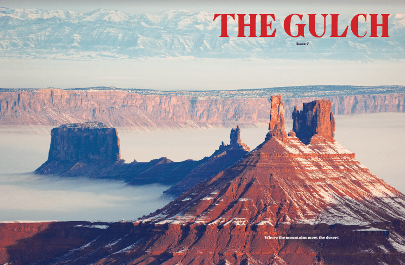
This story is published in issue 7 of The Gulch. Subscribe here.

Like a lone desert tower, I sit on the red dirt, eyeing a storm over Navajo Mountain. It’s January, a cold and dark time to be out camping, even in the desert, but I cannot resist any opportunity for quixotic exploration across the Colorado Plateau. Be it canyons, history or artifacts, this is a place layered in secrets, steeped in mystery and covered in controversy.
During my explorations in the Southwest, my mind often bushwhacks through time. To a time long before Glen Canyon was dammed, before white men put this region on a map, and before humans stepped foot where dinosaurs roamed. My imaginary time travel has taken me down narrow slot canyons with Everett Reuss, on bumpy covered wagon rides down Hole in the Rock road, and to corn storage hubs in ancient Puebloan hideouts. Despite the perception that the golden age of discovery is long over here, the shifting layers of sand, strata and politics still draw a certain breed of mad ones, fools and wanderers as the landscape calls out over the faint zephyr winds, “Explorers wanted.”
So, on this trip back in time, I join Ansel Hall, perhaps best known and revered for his role as the National Park Service’s first chief naturalist between 1923-30. His efforts within the park system are punctuated by founding the first park museums and other educational endeavors, including self-publishing his own visitor guidebooks when the government would not produce them to his standards. A California native (like myself), Hall was entranced with exploring the Sierra Nevada, starting out as a ranger in Sequoia National Park and working his way up the Park Service hierarchy always with a focus on education.
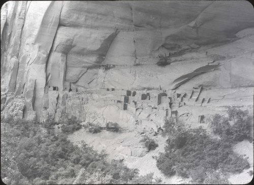
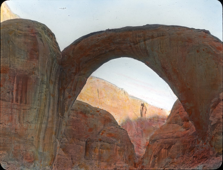
In Kayenta, Ariz., circa 1932, alongside prominent local explorer John Wetherill, Hall became increasingly entranced by the area’s densely pocketed nooks, slithering canyons and vision-gripping mountains. “One cannot be long in the southwest without crossing the trail of John Wetherill,” Hall explains in his first “Help Wanted” ad, hoping to recruit 10 willing explorers (1933). “In the (eighteen) eighties he discovered Cliff Palace and many of the spectacular ruins of the Mesa Verde. Rainbow Bridge, Betatakin, Keet Seel, Inscription House and dozens of other names have been added to the map through his inquisitive and energetic quest for what lies on the other side of the mountain.”
To some, Wetherill was often considered less than savory in his exploratory and excavation methods. In the academic and conservations worlds, his process was a little more “cowboy” than other professionals in his field:
“‘Look at this!’ (Wetherill) walked over to the corner of the long low room and dragged out an enormous three-foot bone that he had found the week before, with the remark that he, ‘guessed the rest of the beast is still mostly underground.’” (Hall, A. California Monthly, Vol. 30 “Explorers Wanted,” 1933). Despite his lack of formal training, there is no denying his pivotal contributions to archaeology in the Four Corners.
Hall’s own appetite for adventure extended beyond his home turf, and his extensive collection of diaries detail wanderings through Madrid and Paris where he took in local gastronomy, became enamored with waitresses and toured museums. I imagine Hall and Wetherill out in the canyons on an idyllic fall afternoon trading stories. As Hall brings up his Central American travel exploits, Wetherill, true to salty local style, is not impressed, “Why go to foreign countries? There’s plenty of exploring to be done right down in this country; and as for scientific work – well, it’s hardly been touched.” (Hall, A. California Monthly, Vol. 30 “Explorers Wanted,” 1933). Hall, like so many who arrived in the Southwest before (and after him) must have been swept away in this prophetic statement while taking in the statuesque views of the Four Corners region, leading to the deepest rabbit hole of all –conservation. The duo put their crafty minds together, dreaming up an expedition with an end goal of a new national park.
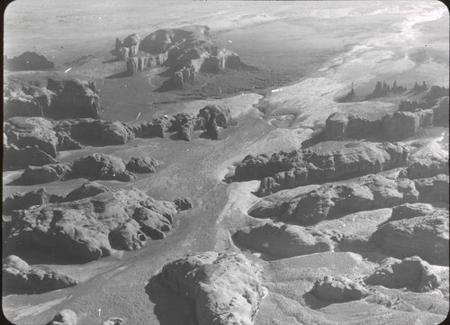
The area in Hall and Wetherill’s discussion was roughly 700 square miles between the Colorado and San Juan rivers on Navajo tribal Land. Their proposed national park is quite literally filled in with red crayon on an original USGS map and encompasses a vast amount of landmark terrain, features and cultural sites. To launch the park proposal, Hall organized the Rainbow Bridge Monument Valley Expedition in 1933. A Depression-era project, on paper the expedition was something that should not be, and yet flourished in spite of the economic draught.
The RBMV Expedition shifted from a one-season project to a behemoth production over the span of five years (1933-38) and is considered one of the last “great” expeditions of this scale. The primary objectives were ambitious: produce accurate topographical maps of the area; contribute significant discoveries to the fields of biology, geology, paleontology and archaeology; and advance education, outdoor experience and protection for the area.
Hall was known to many as a shrewd businessman and romantic idealist but orchestrated the impossible to fund this mission. With minimal federal dollars, he pulled together corporate sponsors like Ford, Gilbuck Boats and Leica Cameras to donate funds, vehicles and equipment in exchange for photographs, stories and film from the expedition to be used in ads. The expedition’s 1938 estimated operating expense report tallies the costs at $6,000 for travel, commissary, motor, pack, haul, science, equipment, buildings, contingencies and misc., and 43 men. With inflation, that is over $105,000 today.
Hall’s “Help Wanted” ads targeted young lads with disposable income, projecting an opportunity for wild west excitement and the summer adventure of a lifetime, for $275. His charismatic recruitment rallied more than 250 applicants over the course of five years. “Does it seem strange to ask a man to pay for the privilege of working hard, living entirely out of touch with civilization for a couple of months, and possibly even enduring some measure of physical hardships?” (Hall, A., “Explorers Wanted.”)
Expedition artists sat on canyon ledges to paint romantic scenes of Rainbow Bridge, as aerial photographers soared in planes overhead capturing stunning panoramic photographs of the indescribably unique landscape. On the ground, teams of strong, hearty guys hauled excavation gear by pack mule to remote locations in scorching heat. With no trails to follow, and sand storms and cloud bursts mentioned in nearly every journal entry, the expedition members were privy to an experience precious few were privy too – summer monsoon season OUT in the desert. They dealt with unbearable waves of heat slashed by torrents of rushing water, sometimes from storms as far as 50 miles away and indiscriminate lightning strikes in the exposed terrain. Perhaps no other season and no other place can remind humans that we are just animals at the mercy of the land. Water and food were necessarily rationed, yet photos show crew members crawling happily exhausted out of their tents in the early morning for that first cup of coffee, sun peeking over the canyon rim.
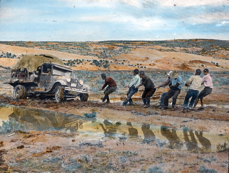
Maps used during the expedition show swaths of roadless land, requiring Hall’s assemblage of Ford vehicles to overland through sand dunes, washes and the same clay that almost stuck my Jeep this morning. Old expedition photos of men pushing the Fords in the most motley of places does not hint at hardship. In nearly every photograph, those toiling in the exposed sunlight, descending perilous cliff bands, toppling over rapids in small boats, are smiling.
“Right now the spirit of adventure runs high.” (Hall, A., Adventures in Crooked Canyons, a Radio Address Over KGO, 1936)

***
My Jeep’s tires leave behind a trail of mud on the highway as Ansel and I head past Glen Canyon Dam and take it due north, past Navajo Mountain, Tsegi Canyon and Monument Valley. We pull over in Valley of the Gods and make camp beneath the Super Blood Wolf Moon and watch the eclipse. The shadows of rock monoliths fade to black as the moon bleeds red, and there is no place we’d rather be. Without the noise of news channels or the distraction of Netflix, there is nothing to do except watch the universe move. For all the destruction we humans inflict on wilderness, this is one of the reasons we need it most.
The next morning, we take off for a run into an oncoming January storm on turf Ansel so romantically wanted to protect. With each gust of biting wind, I hear the submerged canyons, the rock art and the rapids of Glen Canyon shouting not so distant warnings. Valley of the Gods is no longer a part of Bears Ears National Monument. No major oil or gas development has occurred yet, but it is mere miles as the red tail hawk flies from glaring reminders that the worst can happen. While still federal public land, this place is far less protected from mining and oil leases than during its brief monument tenure. As we run on, leaning into the sleet, I ask Hall if he ever imagined the toll politics and destructive industries would take upon this once undamaged landscape. Of course, a man of his wit surely had this foresight – Hoover Dam began construction in 1931. Soaked like desert pack rats caught in a flash flood, we run back to the Jeep and return to the road, bound for Mancos and Durango.
Ansel and I ponder the land recently slashed by President Trump from Grand Staircase Escalante National Monument, this once-protected landscape, adjacent to the massive cement wall that is Glen Canyon Dam. Beyond the 185-mile long reservoir of Lake Powell, what remains of the also-reduced Bears Ears National Monument sits in close quarters to holes carved deep in the earth to extract uranium. The most recent partial government shutdown brought critical public land protection and related research efforts to a grinding halt over funding roadblocks for Donald Trump’s proposed border wall. Among many other complicated issues, a wall would impose serious disruption to critical wildlife corridors in an ecologically sensitive region. Like ripples down the Colorado River that suddenly stop at Lake Powell, it only requires flipping a few chapters back to see we are not witnessing anything new.
Both Hall and Wetherill once made their homes in Mancos, where they worked at Mesa Verde National Park. Wetherill discovered the ruins that would become Cliff Palace, and Hall took charge of concessions in 1937. Excited and ready to dig deep into this story, I spend the next few days with Ansel touring Mancos and excavating the expedition’s photo archives housed at the Center of Southwest Studies at Fort Lewis College. Once inside the terrain of boxed archives, the RBMV Expedition is no longer left to my imagination – I am holding and reading the very journals Ansel penned with his desert loving hands.
“In these days most of us believe that exploration is practically a thing of the past. We envy our pioneering grandfathers, who made their way west into a land of the unknown. During the past three quarters of a century, our frontier has been pushed back, until there is very little wilderness left.” (Hall, A., Adventures in Crooked Canyons, Radio Address Over KGO, 1936)
“What discoveries may lie ahead of them, nobody knows. That is what makes exploration such a fascinating game.” (Hall, A., Adventures in Crooked Canyons, a Radio Address Over KGO, 1936)
We comb through black-and-white photos of smiling young men frolicking naked in the San Juan River, pushing vehicles through sand and marveling at ancient Puebloan structures. These are activities that resonate with anyone who has ever spent considerable time in the desert Southwest. However, there is a striking dissonance in many of these photos –specifically those taken in Glen Canyon – familiar experiences in a (currently) extinct place. As I thumb through the photos of placid water, sandstone towers, side canyons and sandy shorelines now submerged, Ansel attempts to wipe my tears but I step away. I don’t want to flood these black and white canyons.
“Men floating down the river on air mattresses. One sits up and mattress folds like a chair. Ends in free-for-all-struggle.” (Down the Colorado, Photo Journal
Amongst the serious documentation and harrowing reminders of the devastation an area like Glen Canyon has encountered, humorous and gleeful play breaks shake me back to my natural optimistic state – the joy of experiencing these places, after all, is why these men invested in this expedition; why I am invested in stories like these. I wipe my tears and refocus on the incomprehensible swath of terrain still out there, calling me, and Ansel, onward.

A few weeks earlier, I met up with archaeologist Andrew Christenson over a greasy diner breakfast in Prescott, Ariz. Christenson is considered to be the leading research expert on Hall and the RBMV Expedition. He curated many of the materials now found at the Center of Southwest Studies, in addition to spending time with living members of the expedition. Christenson feels that the expedition’s most significant contribution is placing discoveries like Cliff Palace, Keet Seel and Tsegi Canyon into historical context, helping to form the cultural time sequence we reference today from Basketmaker to Puebloan.
Other successes include utilizing aerial photographs to study the distribution of vegetation across the region. Birds of the Navajo Country was published. Rattlesnake venom was gathered to produce snakebite serum. Dinosaur tracks were uncovered, and the fossil of a small bipedal dinosaur named Stegosaurus hall was discovered, a direct nod to Hall.
Yet, there would be no national park – Hall’s five-year vision quest could almost be deemed a failure. Given the duration, financial backing and manpower, groundbreaking discoveries were minimal. Even producing accurate topographic maps, one of the main objectives, was too difficult, based on the topography of the tormentingly twisted landscape.
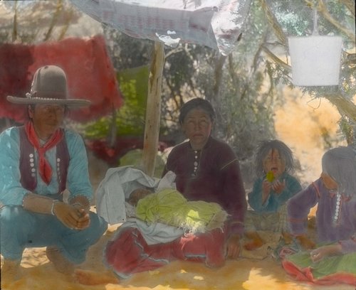
This is also a convoluted relief, as so much of the land in question already belonged to the Navajo Nation. During my research at the Center’s archives, I longed to come across documented reasoning for Ansel’s unjustifiable scheme to stake a national park there. Was the expedition a noble project or a modern evolution of manifest destiny? Hall did write a proposal in 1937 for the Navajo to take the reins for future recreation and tourism on their land (specifically in Tsegi Canyon) while maintaining their traditional way of life, not by attempting to change their environment, but by adapting with it.
“I propose to encourage the Navajo to live in their traditional way – to raise sheep and horse – to weave rugs – to develop their own arts and crafts – and also to profit from the influx of tourists rather than being pushed aside by them.” (Hall, A., Plan for the Northern Navajo Country, 1937)
Hall was willing to pull his own funds, rally corporate support and quit all of his other endeavors to bring this vision to life. While I cannot say that any of this justifies the planned park, it does contextualize Hall’s personal political leanings and life’s mission. One can only hope that had the national park proposal passed, Hall would have been at the forefront of rallying for native involvement, profit and especially rights within the boundaries for traditional practices.

Ironically, the creation of Hall’s national park would have prevented Glen Canyon from being dammed. Damned if you do, damned if you don’t – the cryptobiotic crust of this landscape is impossible for anything to tread lightly upon. Glen Canyon itself was the tradeoff to protect the Green River from being dammed near Dinosaur National Monument. But as Hall prophesized, we are running out of wilderness to be used as trade.
***
I’ve come to understand that public lands management is not a black-and-white chess match but more like watching a once blank map get bisected by highways, mines, smokestacks, concession stands, political bargaining and potentially even walls. I find it impossible not to carry the romantic idealism from my time travel with Ansel forward. With the recent government standstill, I shift my energy to what I can do.
Amongst folks most devoted to this place, I am warmed on a 4-degree morning here in Mancos, by the tight-knit fabric holding together Stegner’s “Geography of Hope.”
Recently passed on to me via email, I read about a federally employed archaeologist in Prescott offering to volunteer his free time for local projects. This got my muddy wheels spinning. Beyond my willingness to explore, observe and report with my hands and feet, I am not a scientific professional. Nor was Ansel or most of the men on his expedition. I’ve sent out multiple emails asking if I may volunteer my time for archaeological, paleontological and mining clean up around the Colorado Plateau. It’s time I get back out there and explore the terrain that brought me to this place in the story, to take positive steps for its future.
But for now, I’ll stroll with Ansel in the snow around Canyon of the Ancients until I find out if there are still any explorers wanted.
Editors Note: All photos and lantern slides featured in this article were captured by original members of the RBMV expeditions and featured courtesy of the Center for Southwest Studies.
Morgan ran away to the Southwest two years ago without any plans other than to explore the canyons while living in her Jeep. The story found her out there though, and she was asked to write the first guidebook specific to Bears Ears (The Best Bears Ears National Monument Hikes). Her Four Corners-inspired writing is focused on public lands and human powered adventure/exploration. Her next books, Outlandish: Fuel Your Epic and The Best Grand Staircase National Monument Hikes unleash into the wild this spring.